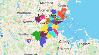
Boston Zip Code Map: How 021xx Shapes the City’s Identity, Economy, and Everyday Life
Boston Zip Code Map: How 021xx Shapes the City’s Identity, Economy, and Everyday Life
The ZIP code system in Boston, from 02108 to 02137, encodes centuries of urban growth, racial and economic stratification, and infrastructure planning. These five digits determine not only mail routing but also access to school quality, transit convenience, housing affordability, and even perceptions of safety. This article explains how Boston’s zip codes emerged, how they function today, and why they remain central to debates about opportunity, mobility, and municipal policy in one of America’s oldest large cities.
Informal neighborhood names such as Back Bay, South End, and East Boston often guide how residents describe where they live, but the formal Boston zip code system imposes a precise, machine-readable geography on a dense and historically layered metropolis. Developed alongside the national ZIP system in the early 1960s and expanded as Boston grew through annexations and redevelopment, these codes were designed to streamline mail sorting amid rapid suburbanization. Each code is anchored to specific delivery sections, carrier routes, and clusters of post offices, but over time they have also become shorthand for distinct housing markets, civic identities, and public service challenges.
Understanding Boston’s zip codes requires recognizing the dual logic that shaped them: operational efficiency for the U.S. Postal Service and sociopolitical reality on the ground. The city’s layout along a narrow peninsula, its harbor islands, and a radial street plan inherited from colonial times meant that neat geometric grids were often impractical. As a result, Boston’s zip boundaries frequently follow major thoroughfares, rail lines, and topographic features, producing irregular shapes that can cut sharply across neighborhoods. While this sometimes leads to counterintuitive assignments—where a short walk can move a resident from one zip to another—it also reflects compromises between administrative goals and lived urban experience.
The origins of Boston’s specific codes lie in the mid-20th century, when the postal service sought a system that could handle rising volumes of mail without proportional increases in labor. Boston was among the major cities that received its initial set of codes as the national ZIP system launched, with 02108 assigned to parts of the downtown financial district and nearby institutional zones. Over time, as new developments emerged and neighborhoods sought distinct identities, additional codes were added, such as 02130 for much of Allston and parts of Brighton, or 02125 for portions of Dorchester and Mattapan. These designations were not merely administrative; they responded to demands from community leaders and real estate actors who recognized the marketing and service implications of identifiable postal codes.
In practice, Boston zip codes correlate strongly with patterns of wealth, race, and access to opportunity, even as they are not perfect predictors of individual experience. Within a few miles, residents may encounter sharply different zip-based realities in terms of school funding, commercial investment, and exposure to environmental stressors. Real estate listings, mortgage algorithms, and even some employer screening processes can inadvertently treat zip codes as rough proxies for risk and desirability, reinforcing existing inequalities. Public programs that rely on geographic targeting, from heat relief initiatives to small business grants, must therefore grapple with how zip boundaries align—or fail to align—with actual community needs.
Boston’s transit system further illustrates the importance of zip code geography, as subway, bus, and commuter rail lines both shape and respond to these numeric boundaries. Stations often anchor clusters of higher-density housing and retail, creating neighborhoods that are legible in part through their postal identities, such as the corridor around Davis Square in 02140 or the South Station area in 02110. At the same time, riders moving across city lines may shift from one zip to another without leaving the same transit fare zone, highlighting how administrative categories do not always map cleanly onto everyday mobility. For city planners, advocates, and residents, understanding these overlaps is essential for designing services that follow people’s actual routes and routines rather than arbitrary lines on a map.
The relationship between Boston zip codes and housing markets is especially visible in how prices, inventory, and perceptions of safety vary across relatively short distances. In areas coded as 02116, which includes parts of the South End and lower Roxbury, high-end condominiums sit a few blocks from subsidized housing and historically lower-price apartment buildings, producing a mosaic of values and experiences within a single postal designation. Meanwhile, neighborhoods coded as 02132, encompassing parts of Dorchester and Fields Corner, reflect long-standing residential stability alongside ongoing efforts to attract new investment. Because lenders, insurers, and data vendors often use zip-level information to assess risk, these codes can indirectly influence who receives offers for mortgages, home improvement loans, or even rental applications.
Education further sharpens the stakes of Boston zip codes, as families navigate a mix of district schools, charter schools, and exam schools whose catchment areas do not always align with postal boundaries. Parents may weigh the convenience of a nearby district school coded, for example, as 02120 against the academic reputation of a charter in another zone, factoring in not only test scores and extracurricular offerings but also perceived safety and transportation logistics. Research on educational opportunity in Boston has shown that families with more information and greater flexibility tend to exploit these nuances, while those with fewer resources may remain constrained by the zip-based geography of assignment. This dynamic feeds into broader debates about equity, school choice, and how to balance neighborhood cohesion with access to high-quality options.
Health outcomes in Boston also intersect with zip code patterns, as environmental conditions, access to care, and chronic stress associated with neighborhood disadvantage accumulate in recognizable ways. Areas with older housing stock, heavy traffic, and limited green space—often reflected in codes such as 02124 or certain sections of 02122—may experience higher rates of asthma and other respiratory conditions compared with quieter, better-resourced districts. Public health officials increasingly use zip-level data to target interventions, from lead inspection campaigns to heat warning systems, recognizing that administrative boundaries can help mobilize resources even as they risk oversimplifying complex community needs. Community organizations, meanwhile, sometimes embrace these codes as a way to claim visibility and argue for investments in parks, clinics, and safe walking routes.
Beyond policy and services, Boston zip codes play a subtle but significant role in cultural identity and social perception. Residents may say they are from “02129” or “02125” as a way of signaling local belonging, signaling not only a mail route but also networks of kinship, shared history, and mutual recognition. Artists, activists, and entrepreneurs have leveraged these codes in branding and organizing, from neighborhood-specific social media groups to campaigns around tenant protections and small business support. At the same time, the rise of data-driven marketing and predictive policing can amplify stereotypes tied to certain codes, making it crucial for journalists, officials, and community members to scrutinize how these categories are used and interpreted.
Looking forward, Boston’s zip code system will continue to evolve alongside demographic shifts, new development, and technological change in mail delivery and location-based services. As the city invests in climate resilience, transit expansion, and affordable housing, planners will need to consider how zip-based metrics can be used thoughtfully without reinforcing existing divides. Collaborative efforts that bring together residents, neighborhood-based nonprofits, city agencies, and the postal service itself may help ensure that these familiar five digits serve not as rigid boundaries but as tools for more equitable, data-informed decision-making. In a city built on layered histories and constantly negotiating its future, understanding Boston’s zip codes offers one lens through which to see how geography, institutions, and everyday life intersect.
Related Post
What Is Boston Zip Code: The Ultimate Guide to Understanding ZIP Codes in Boston
Boston Zip Code USA: Cracking the Numerical DNA of a Historic Metropolis
East Boston Zip 02128: How a Small Code Defines a Dense, Dynamic Neighborhood
Beacon Hill Boston Zip Codes Real Estate And Lifestyle: The Premium Of History And Exclusivity