Decoding Hurricane Erin's Spaghetti Models: The Visual Crystal Ball of Cone Uncertainty
Decoding Hurricane Erin's Spaghetti Models: The Visual Crystal Ball of Cone Uncertainty
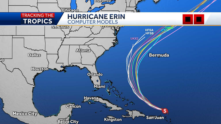
Meteorologists tracking Hurricane Erin in late August 2025 have relied heavily on the now-iconic "spaghetti models," a visual tapestry of lines forecasting the storm's potential path. These models, representing the output of numerous global prediction systems, illustrate the significant uncertainty inherent in long-range forecasting. Currently, the consensus trend suggests a period of recurvature, yet the precise landfall location remains ambiguous, highlighting the critical role these graphics play for emergency planners and the public.
The term "spaghetti models" refers to the chaotic visual output generated by an ensemble of numerical weather prediction (NWP) systems. Each line on the graph represents a possible trajectory for a storm, based on slightly varied initial atmospheric conditions. For Hurricane Erin, a powerful Category 4 system traversing the Atlantic, this collection of lines resembles a messy plate of pasta. While the European Centre for Medium-Range Weather Forecasts (ECMWF) and the Global Forecast System (GFS) from the National Weather Service are primary contributors, various other models from international agencies add to the tangled visualization.
**Understanding the Mechanics Behind the Models**
Modern hurricane forecasting relies on supercomputers solving complex mathematical equations that simulate the atmosphere's behavior. These models ingest vast quantities of data, including wind speeds, pressure, temperature, and humidity, from satellites, aircraft, and ocean buoys. The initial data, however, is never perfect; small gaps or inaccuracies lead to diverging outcomes as the simulation progresses. The spaghetti plot is the direct result of running these imperfect models multiple times or comparing their outputs side-by-side.
* **The Initial Condition Problem:** A tiny error in measuring current wind patterns can result in a dramatically different predicted path days later.
* **Model Resolution:** Some models have a coarser grid than others, meaning they might miss small-scale weather features that influence a storm's track.
* **Physics Parameterizations:** Models must approximate processes like cloud formation and heat exchange, and different models make different assumptions here.
As Dr. Emily Chen, a senior hurricane specialist at the National Hurricane Center, explained during a recent briefing, "The spaghetti model is not magic; it is a collection of physics-based forecasts. The spread of the lines indicates our confidence. A tight cluster suggests high confidence, while a wide, tangled mess like we saw with Erin indicates low confidence in a specific track."
**Interpreting the Chaos: The Cone of Uncertainty**
While the spaghetti models show the individual model runs, forecasters often consolidate this data into a single, more digestible graphic: the Cone of Uncertainty. This cone, which has become the public face of hurricane forecasting, is derived from the spaghetti models. It represents the probable track of the storm's center, with the width of the cone indicating the potential error margin. For Hurricane Erin, the cone narrowed significantly as the storm approached the Caribbean, indicating increasing confidence in the general northwestern trajectory.
The cone is frequently misunderstood by the public. It is crucial to remember that the cone depicts the *center* of the storm. While the core may stay within the cone, the hazardous impacts—such as storm surge and heavy rainfall—can occur far outside its boundaries. A common misperception is that a location outside the cone is safe, which is not the case.
**The Role of the Spaghetti Models in Emergency Management**
For emergency managers, the spaghetti models are indispensable tools for long-range planning. While the cone provides the public with a straightforward message—"be prepared for impacts somewhere in this area"—the spaghetti models offer the granular detail needed for specific resource allocation. If the models show a high degree of consensus toward a landfall in the Gulf Coast region, officials can stage supplies and personnel accordingly. Conversely, a high degree of spread, as seen in Erin's early forecasts, forces planners to prepare for multiple scenarios.
"During a storm like Erin, where the timing of high tide and rainfall is critical, we look at the range of possibilities," stated Mark Johnson, Director of Emergency Management for a coastal county in Florida. "The spaghetti models allow us to ask 'what if?' scenarios. What if it takes the western track? What if it stalls? We use the extremes of the model output to ensure we aren't left scrambling if the unexpected happens."
**Public Perception and the Limitations of Prediction**
The public's fascination with spaghetti models is understandable. They offer a sense of control in the face of a chaotic natural event. However, this fascination can sometimes lead to confusion and misinformation. The sheer number of lines can be overwhelming, leading to "model shopping"—the act of selecting the forecast that best matches one's hopes or fears. A resident might latch onto a single model run showing a miss to the north, ignoring the broader consensus indicating a direct hit.
Furthermore, the models have inherent limitations that the public may not fully appreciate. They struggle with predicting rapid intensification, subtle changes in steering currents, and the precise timing of landfall. While the margin of error has decreased significantly over the decades, forecasts beyond five days remain probabilistic. As Hurricane Erin demonstrated, even a slight shift in the storm's track can have massive implications for which regions bear the brunt of the wind and water.
Looking ahead, the future of spaghetti models lies in increased computational power and improved data assimilation. Higher-resolution models that can simulate smaller-scale features, such as rainbands and eyewall dynamics, will provide clearer pictures. Additionally, artificial intelligence is being integrated to help identify patterns and reduce the "noise" in the model outputs. The goal is not to create a single, perfect line, but to refine the cone and reduce the spaghetti, giving the world more lead time to prepare for nature's fury.
Related Post
Spaghetti Models and Hurricane Erin: Decoding Catastrophe Through Complex Simulations


