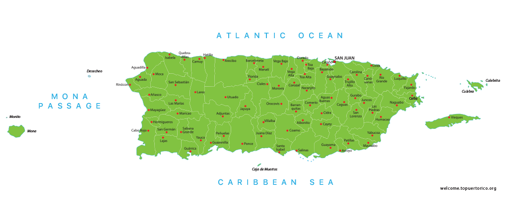
Decoding the Caribbean Hub: Unlocking the Secrets of Puerto Rico Zip Code Systems
Decoding the Caribbean Hub: Unlocking the Secrets of Puerto Rico Zip Code Systems
Navigating the intricate web of Puerto Rico zip codes reveals the unique logistical framework of this U.S. territory, where numerical prefixes designate distinct geographic zones. This system, largely aligned with the mainland United States while incorporating local nuances, serves as a critical tool for efficient mail delivery and geographic identification. Understanding these codes is essential for businesses, residents, and visitors alike to ensure seamless communication and commerce across the island.
The implementation of zip codes in Puerto Rico operates under the broader umbrella of the United States Postal Service (USPS), yet it reflects the island's specific demographic and geographic characteristics. From the bustling metropolitan area of San Juan to the more rural municipalities of the interior, each segment of this unincorporated territory is assigned a unique numerical identifier. These codes facilitate not only the delivery of letters and packages but also the collection of vital data for governmental and commercial purposes. As Puerto Rico continues to develop and rebuild, its postal coding system remains a foundational element of its administrative infrastructure.
The Anatomy of a Puerto Rico Postal Code
A standard Puerto Rico zip code is a five-digit number, similar in format to those used in the 50 states. However, the geographic and historical context behind these numbers is distinct. The first digit or the first two digits typically indicate a sectional center facility (SCF) or a major city cluster. For instance, codes beginning with "009" are predominantly associated with the San Juan metropolitan area, encompassing municipalities like Carolina, Trujillo Alto, and Bayamón. This prefix immediately signals to postal handlers and systems that the mail destination is within this dense urban region.
Diving deeper into the structure reveals further specificity. The subsequent digits narrow down the location to a particular post office, a group of streets, or a specific delivery route. For example, within the 009 prefix, codes like 00901 through 00932 are allocated to various sectors in San Juan and its immediate neighbors. This granularity ensures that automated sorting machines and local carriers can route mail with precision. The system is designed to handle the high volume of mail, particularly to and from the mainland United States, which constitutes a significant portion of the territory's correspondence.
* **006 to 007:** These prefixes are generally assigned to various towns and regions in the western and southwestern parts of the island, such as Mayagüez (00680, 00690) and Cabo Rojo (00677).
* **007 to 008:** This range covers many central and eastern municipalities, including Caguas (00725, 00739) and Gurabo (00778), reflecting the island’s population distribution.
* **009:** As previously noted, this is the dominant code for the San Juan agglomeration, the economic and cultural heart of Puerto Rico.
* **00927, 00928, 00929:** Specific codes within the 009 range that serve dense residential and commercial zones in San Juan itself.
History and Evolution of the System
The adoption of zip codes in Puerto Rico was not an instantaneous process but rather an evolution that mirrored the territory's integration into the broader U.S. economic and administrative system. Before the widespread implementation of five-digit zip codes in the 1960s, mail routing relied on a combination of city names, station numbers, and sometimes vague regional indicators. This older method was inefficient and prone to errors, especially as trade and communication with the mainland increased. The introduction of the zip code system was a necessary modernization step.
The transition required careful planning to accommodate the unique realities of Puerto Rico. Unlike states, the territory did not have a gradual, state-by-state rollout. Instead, the USPS implemented the system comprehensively, recognizing the logistical challenges of an island geography. A postal historian might note, "The implementation in Puerto Rico was a logistical masterclass, adapting a mainland system to a complex island terrain and a dense urban core like San Juan. It was about integrating a territory into the national grid without the same administrative history as the states." This integration was crucial for facilitating commerce and personal communication between Puerto Rico and the continental United States.
Over the decades, the system has had to adapt. Population shifts, urbanization, and the occasional devastating hurricane have necessitated adjustments. New developments require new codes, while areas experiencing significant depopulation might see consolidations. The fundamental five-digit structure has remained, but the specific boundaries and assignments have evolved to reflect the changing landscape of the island.
Practical Applications and Modern Challenges
For residents and businesses in Puerto Rico, understanding and correctly using the zip code is more than a matter of postal etiquette; it is a practical necessity. E-commerce platforms, billing systems, and even some government forms often require a valid U.S. zip code. Using the correct code ensures that online purchases arrive promptly, that invoices are processed without delay, and that official communications are received. A local entrepreneur in Ponce (zip code 00716) noted, "For our online store, getting the zip code right is the first step to ensuring a package doesn't get stuck in transit or misrouted. It's the digital equivalent of a correct address."
The system also plays a role in demographic analysis and resource allocation. Government agencies and researchers use zip code-level data to study population trends, track economic indicators, and plan for public services. For instance, data from zip codes in areas like Dorado (00646) or San Juan (00918) can provide insights into tourism impact or urban development patterns.
However, the system is not without its challenges. The growth of informal settlements and the constant evolution of urban neighborhoods can sometimes outpace the official assignment of zip codes. This can lead to areas where residents are unsure of their exact code, leading to delivery delays. Furthermore, the reliance on a five-digit system can sometimes cause confusion when similar codes are assigned to nearby but distinct locations. The ever-present threat of natural disasters also poses a risk, as damaged infrastructure can temporarily disrupt the assignment and delivery processes associated with specific zip codes. Despite these hurdles, the system remains the bedrock of mail delivery and location identification across the island.
Looking Forward: Technology and the Zip Code
As technology advances, the role of the zip code is also evolving. While the five-digit system remains central, the integration of geocoding and GPS technology is adding new layers of precision. For instance, some logistics companies now use the zip code as a starting point for route optimization, ensuring that delivery drivers can navigate the island's mountainous regions and congested city streets with maximum efficiency. The USPS itself is exploring ways to leverage more detailed address data, potentially moving towards a more granular system in the future, although any major change to the familiar five-digit format remains a distant prospect.
For now, the Puerto Rico zip code continues to serve as a vital link between the island and the world. It is a numerical shorthand that encapsulates a complex geography, a rich history, and a dynamic present. Whether it is a student sending care packages to family, a business shipping goods to the mainland, or a government agency analyzing census data, this seemingly simple string of digits remains an indispensable tool for connecting Puerto Rico to the broader global community. Its continued relevance is a testament to the enduring importance of organized logistics in a connected world.
Related Post

Puerto Rico Zip Codes And Us State Codes: A Comprehensive Guide

Puerto Rico Zip Code Guide: Unlocking the Island's Economic and Cultural Dynamics
Puerto Rico Zip Code Guide: Understanding Us Zip Codes Explained

The Hidden World of Puerto Rico Zip Codes: Uncovering the Island's Geography and Identity