Hurricane Erin Tracking: Real-Time Path, Intensity, and Potential Impact Analysis
Hurricane Erin Tracking: Real-Time Path, Intensity, and Potential Impact Analysis
As Hurricane Erin rapidly organized in the far eastern Atlantic, forecasters initiated detailed tracking protocols to monitor its trajectory, intensity fluctuations, and potential landfall scenarios. This article dissects the latest observational data, model guidance, and expert analysis surrounding Erin, providing a comprehensive overview of its projected path and potential implications for coastal regions. Understanding the mechanics behind each forecast cone and advisory is critical for public preparedness and informed decision-making in the face of a major tropical system.
The development of a tropical cyclone, particularly one with hurricane potential, triggers a multi-agency response involving meteorologists, emergency managers, and the public. Each stage of the storm's lifecycle, from tropical depression to major hurricane, is meticulously documented and analyzed. The following sections delve into the specifics of tracking methodologies, current storm status, and the factors influencing future evolution.
Genesis and Initial Development
Hurricane Erin originated from a robust tropical wave that emerged off the western coast of Africa. Satellite imagery revealed a concentrated area of deep convection with improving organization, leading the National Hurricane Center (NHC) to designate it as a tropical depression. Rapid strengthening ensued, with bands of thunderstorms wrapping tightly around a developing center, signaling its upgrade to a tropical storm and subsequent naming as Erin.
Key factors contributing to its rapid development included:
- Sea surface temperatures exceeding 28 degrees Celsius, providing ample energy.
- Moderate to low vertical wind shear, allowing the storm structure to remain vertically aligned.
- A moist mid-level environment, which facilitated sustained convection and outflow.
Forecasters immediately began tracking its west-northwestward motion, noting the influence of a strong subtropical ridge over the Atlantic. This steering pattern is expected to persist in the short term, directing Erin toward the open ocean. However, subtle shifts in the ridge's position could significantly alter the long-term track.
Current Status and Observations
As of the latest advisory, Hurricane Erin exhibits a well-defined eye surrounded by intense eyewall convection. Data from reconnaissance aircraft indicate maximum sustained winds of approximately 120 knots, classifying it as a Category 3 major hurricane. The central pressure has fallen steadily, reflecting continued intensification.
Key observational metrics include:- Location: Positioned approximately 800 miles east of the Lesser Antilles.
- Movement: Tracking west-northwest at 15 knots.
- Intensity: Sustained winds of 120 knots with higher gusts.
- Pressure: Estimated central pressure of 960 mb.
Satellite imagery from geostationary platforms shows a symmetric structure, with minimal dry air intrusion. This symmetry is a positive indicator for maintaining intensity, although close monitoring of environmental changes is essential. The storm's interaction with the Saharan Air Layer remains a variable, as dry entrainment can disrupt circulation and reduce convection.
Projected Track and Intensity
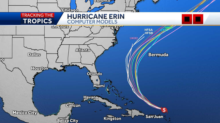
Predicting the future path of Hurricane Erin involves analyzing a suite of global and regional models. The consensus among forecasters suggests a continued west-northwest trajectory over the next 48 to 72 hours. However, significant uncertainty exists beyond this period, as subtle changes in steering flow can lead to divergent solutions.
The official track forecast cone, representing the probable path of the center, has fluctuated slightly with each advisory. Residents in the Leeward Islands should monitor updates closely, as even minor shifts in the track could bring the outer rainbands or stronger winds onshore.
Key factors influencing the track include:- The position and strength of the Bermuda-Azores high.
- Potential interaction with a mid-latitude trough over the eastern United States.
- The storm's forward speed, which can affect interaction with environmental features.
Intensity forecasting presents its own set of challenges. While warm ocean temperatures support strengthening, increasing wind shear and drier air aloft are potential inhibitors. The NHC's intensity consensus model predicts a slight weakening trend as Erin approaches the eastern Caribbean, though this remains subject to change. "We are closely monitoring the interplay between the storm's internal dynamics and the surrounding environment," stated a senior hurricane specialist. "Each system has its own personality, and we must adapt our guidance accordingly."
Potential Impacts and Preparedness
The primary threat from Hurricane Erin in the near term is heavy rainfall and elevated surf along island chains. The Leeward Islands, including Antigua, Barbuda, and St. Kitts, are most vulnerable to tropical storm force winds and flash flooding. A Tropical Storm Watch or Warning would necessitate immediate preparations, such as securing outdoor objects and stocking emergency supplies.
For regions further west, such as Puerto Rico and the Virgin Islands, the risk is currently lower but warrants continued vigilance. Swell generation is a major concern, as life-threatening surf and rip currents can affect beaches thousands of miles from the center. Coastal residents are advised to review evacuation routes and familiarize themselves with local emergency plans.
Action Items for the Public:
1. Stay informed through official channels like the National Hurricane Center and local emergency management.
2. Prepare an emergency kit with essentials like water, non-perishable food, medications, and a battery-powered radio.
3. Develop a family communication plan in case of separation.
4. Avoid coastal areas due to dangerous surf conditions, regardless of the storm's proximity.
The Science Behind the Spin
Understanding how hurricanes form and intensify requires a grasp of fundamental meteorological principles. Hurricanes are heat engines that derive their energy from the warm waters of tropical oceans. As moist air rises and condenses, it releases latent heat, which fuels further ascent and lowers the surface pressure. This creates a feedback loop that can lead to rapid intensification under favorable conditions.
The Coriolis effect, caused by the Earth's rotation, imparts the cyclonic spin observed in these systems. Without this planetary force, organized rotation cannot occur. Hurricane Erin's development is a textbook example of these processes in action, offering a valuable case study for researchers. Data collected from dropsondes—instrument packages dropped from aircraft—provide crucial profiles of temperature, humidity, and wind, which are assimilated into forecast models to improve accuracy.
Looking Ahead
The coming days will be critical in determining Hurricane Erin's ultimate fate. While the current consensus leans toward a trajectory that keeps the main system away from major landmasses, the margin for error is slim. Continuous monitoring and adherence to official advisories are paramount. The lessons learned from past storms underscore the importance of preparation and the unpredictable nature of these powerful meteorological phenomena. As forecasters refine their models and gather more data, the world will remain fixed on the evolving story of Hurricane Erin.
Related Post
alog Ella be Gone: The Cutting-Edge World of Hurricane Erin Tracking Models And Spaghetti Forecasts
Hurricane Erin Tracking The Projected Path And Impact: Latest Models Chart Uncertainty

Hurricane Erin Tracked to Perfection: How iOS Revolutionized Storm Tracking
Hurricane Erin: A Hurricane Tracking Delight – Unveiling the Power of Spaghetti Models and Insights