The Truth Behind the Map: How the Peters Projection Challenges Our View of the World
The Truth Behind the Map: How the Peters Projection Challenges Our View of the World
For decades, the familiar Mercator projection has shaped our perception of geography, subtly distorting the sizes of continents and reinforcing historical power dynamics. The Peters projection emerged as a radical alternative, promising a mathematically accurate representation of landmasses based on area rather than shape. This article explores the origins, principles, and profound impact of the Gall-Peters projection, a map that forces us to question how we see the world.
A Radical Idea Forged in History
The story of the Peters projection is not merely a cartographic footnote; it is a narrative steeped in political and scientific debate. In the 16th century, Gerardus Mercator designed his navigation map to accurately represent compass routes, a feat that came at the cost of significant size distortion, particularly near the poles. This distortion made countries like Greenland and Russia appear disproportionately large compared to regions near the equator, such as Africa.
Enter Arno Peters, a German historian and cartographer. In the 1970s, Peters brought this inequity to the forefront, arguing that the dominant maps were not just inaccurate but an instrument of "cartographic imperialism." He championed a projection created earlier by James Gall and Oscar Sherman, which preserved area, ensuring that one square inch on the map represented the same amount of land everywhere. The result was a map where Africa, often visually diminished, was finally rendered in its true relative scale.
The Core Principle: Area Over Shape
The fundamental difference between the Mercator and Peters projections lies in their priorities. Mercator prioritized shape and angle, making it ideal for nautical navigation but poor for showing size. The Peters projection, a type of equal-area or "equivalent" projection, prioritizes area accuracy. This means:
- Every country and region on the map is proportional to its actual size on Earth.
- While shapes are distorted—continents stretch north-south—the relative size of landmasses is correct.
- This corrected imbalance offers a more equitable visual representation, particularly for the developing nations of the Southern Hemisphere.
Consider Africa. On a Mercator map, it can appear smaller than Greenland. In reality, Africa is 14 times larger than Greenland. The Peters projection corrects this glaring error, presenting a continent whose vastness is impossible to ignore.
Championing a Cause or Promoting a Viewpoint?
Peters did not simply create a new map; he launched a movement. He viewed his projection as a tool for social justice, a way to challenge the Eurocentric perspective that had dominated cartography for centuries. His aggressive marketing and philosophical stance made the map a lightning rod for controversy.
"The Peters projection was a political statement. It was about giving visibility to places that had been systematically minimized,"
— Dr. John G. Keane, Geographer and Historian of Cartography.
This political angle was not lost on educators and institutions. In the late 1980s and early 1990s, the map became a symbol of progressive education in schools across the United States and Europe. School districts adopted it to teach students about global inequality and the dangers of a single perspective. The map became a physical manifestation of the debate over how history and geography are told.
The Controversy Itself Created a Distortion
Despite its noble intentions, the Peters projection is not without its scientific and practical critics. Cartographers argue that every map projection is a compromise. You cannot perfectly represent a 3D sphere on a 2D surface without distorting *something*. While Peters solved for area, he did so at the expense of shape and direction, which became highly skewed, particularly for continents like Europe and North America.
Furthermore, the map's militant adoption by some educational boards was seen by detractors as an ideological overreach. Critics claimed it replaced one form of bias with another, arguing that a balanced education should present multiple maps to foster critical thinking, not promote a single "truth."
The Compromise: The Winkel Tripel Projection
In response to the limitations of both extremes, the National Geographic Society adopted the Winkel Tripel projection in 1998 for its reference maps. This projection attempts to balance the distortion of shape, area, and distance, presenting a more visually pleasing and geographically accurate compromise than either the Mercator or Peters alone.
The Winkel Tripel’s adoption marked a kind of truce in the cartographic wars. It acknowledged that while the Peters projection successfully highlighted a crucial element of global reality—relative size—it was not the sole solution. The goal shifted from finding a single "correct" map to understanding that all maps are tools, each with specific uses and inherent biases.
The Lasting Legacy: A Map That Changed the Conversation
Whether you view the Peters projection as a revolutionary tool or a flawed artifact, its impact on the world of cartography and global consciousness is undeniable. It forced a long-overdue conversation about representation, perspective, and power. It proved that a map is not just a neutral tool for navigation but a powerful cultural artifact that shapes how we understand our world.
Today, the Peters projection is less of a classroom staple than it was in its heyday, but its principles endure. It lives on in the digital maps we use, which often allow users to toggle between different projections. It lives on in the skepticism it instilled, encouraging us to question the images we are presented with. Most importantly, it lives on in the simple, powerful idea that in the vastness of our world, every piece of land deserves to be seen in its true proportion.
Related Post
The Gall Peters Projection: Sparking Debate Over Truth and Bias in World Maps

The Unstoppable Force: Bubliks Halle Triumph A Tennis Showdown
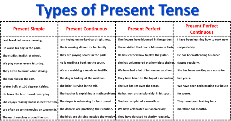
Unlock the Power of the Present Tense: Boost Your English Vocabulary Now!

Santa Fe vs Medellin: Uncovering the Intense Rivalry Between Two of South America's Football Powerhouses